Chaba River
I can’t believe it has been three months since my last packrafting trip. It’s been a busy summer for me. I had a few trips in mind for a while now but it seems like there was always something preventing me from doing them. Looking at the Jasper National Park map back home, I thought of a new potential trip. It included hiking the Fortress Lake Trail all the way to the Athabasca Crossing, where a washed out bridge in 2014 would require a packraft to continue on. From across the river the trail joins the Chaba River, a tributary of the Athabasca, to Fortress Lake in British Columbia. But I wanted to hike the 12-ish kilometers to the headwaters of the Chaba, just below the Chaba Glacier and packraft my way back down the river and continue on the Athabasca to a pull out spot near the highway further North. I invited my friend Martin (MartyUpNorth) once again to join me on this packrafting adventure.
The road to the trailhead was long but never boring, because it’s my favorite time of the year when the snow starts to fall in the Rockies. It always brings back memories of my 2016 visit in Jasper, the trip that changed my life and ultimately brought me here in Alberta!


We packed our rafts and paddles on our backpacks and quickly started to walk at a good pace on the trail. We knew we had 14km to hike before reaching the campground at the Athabasca Crossing. And at this time of the year, we had until 8PM or we would be hiking in the dark.

We reached the Big Bend Campground in no time. 6.3km in the books, but more than 7km to go. Seeing the area under a different light was interesting, especially with the fall colors starting to show.


We stopped not too long after this to grab our headlamps. While the pictures don’t make justice to the amount of light we had, we got to the campsite in total darkness. Hiking in the dark was quite fun. We just made sure to make a little bit more noise as this trail is rarely used these days and a bear encounter was not what we wanted before reaching camp.

We quickly set up our shelters and prepared dinner around a fire. We were both tired. The long drive and even longer hike wore us down pretty fast. The temperature was barely above freezing when we went to bed. I have a very good insulated inflated sleeping pad that protects me very well from the cold ground, but again, I wanted to experiment a few things on this trip and one of them was to sleep only on a closed-cell foam mattress to see how it would feel like in case of an inflatable pad malfunction. I was so tired that night that I decided to postpone this test to the second night.


Cozy in my Six Moon Designs Deschutes Tent, bundled up in my homemade down quilt.
Despite the cold evening, the night was comfortable and I woke up to absolutely no condensation in my tent. Marty too said he had slept surprisingly warm. The sky was slightly overcast but we could tell that the clouds would clear soon and that the sun would be shining. We both packed up quite fast and agreed to have breakfast on the other side of the Athabasca River that was less than 20 minutes away from our campsite. After a quick water refill at a stunning clear water bay created by the overflowing river, we were on our way to the river crossing.


The mighty Athabasca River near where the bridge got washed out.


The spot we settled on for the crossing was calm and just downstream of the small set of rapids is where we set off. There was a nice long sandy beach on the other side that made for an easy place to get out. After inflating our rafts, we climbed down the mini cliff and in no time we were on the other side of the Athabasca River.


My Alpacka Caribou Packraft.


For both Marty and I, being on the other side represented the true beginning of our adventure. I was feeling this adrenaline rush while paddling across the Athabasca. This river is an icon of the Canadian Rockies and is also feared by many because of how mighty it is. Even at this time of the year, the flow was fast and checking for depth, my 5-foot paddle could fully go in without reaching the bottom. I’ve seen a lot of questioning online about the possibility of fording the river. I spent the summer crossing rivers and enjoy doing it, but I would never attempt to cross the Athabasca on foot. But of course, a packraft opens up the possibilities and it proved to be the perfect tool.


As planned, breakfast was eaten while drying our rafts. We took it easy for at least half an hour. I walked along the river while enjoying a tea. The only thing I was thinking about was how great my first summer in the Rockies as an Albertan went. The trips I undertook brought me to some beautiful places. And the Chaba Valley was yet another place I was looking forward to. So off we went along the old trail that leads to Fortress Lake. Our next stop would be the Chaba River, where hikers used to cross it to reach the lake.


While it started with an easy flat trail, some sections were wildly overgrown. But I’ll take an overgrown trail over one with deadfalls!


The red colored pines are the result of an invasion of mountain pine beetles in Jasper. The pines are basically dead from the inside and will end up falling soon.
The Chaba River! As expected from a few satellite imagery pictures I was able to check before leaving, the Chaba is a braided river with therefore lots of channels. Exactly the kind of river I like! That’s where we would leave the trail to make our own. The plan I had was to walk the flats all the way to the headwaters, which accounted for around 12km. But first, we had to find a way to cross a calm but deep channel that was running parallel to the trail.


We ended up bushwacking along the trees, following a few game trails until we found an easy spot to cross and access the river flats.


The views of Mount Quincy and its hanging glacier were stunning and we took advantage of a massive log in the middle of the flats to sit for a while and snack on some granola bars (and also sip on Canadian Whisky).


The reason I like to walk on river flats is because it’s like a constant puzzled itinerary. You might be able to stay on the main gravel bar for a while, but then a sharp turn on the river will make you look and analyze for the next steps to take. We faced these situations more than once. Bushwacking was necessary but it seemed like every time we had to go back into the woods along the river, a faint moose trail was showing us the way.


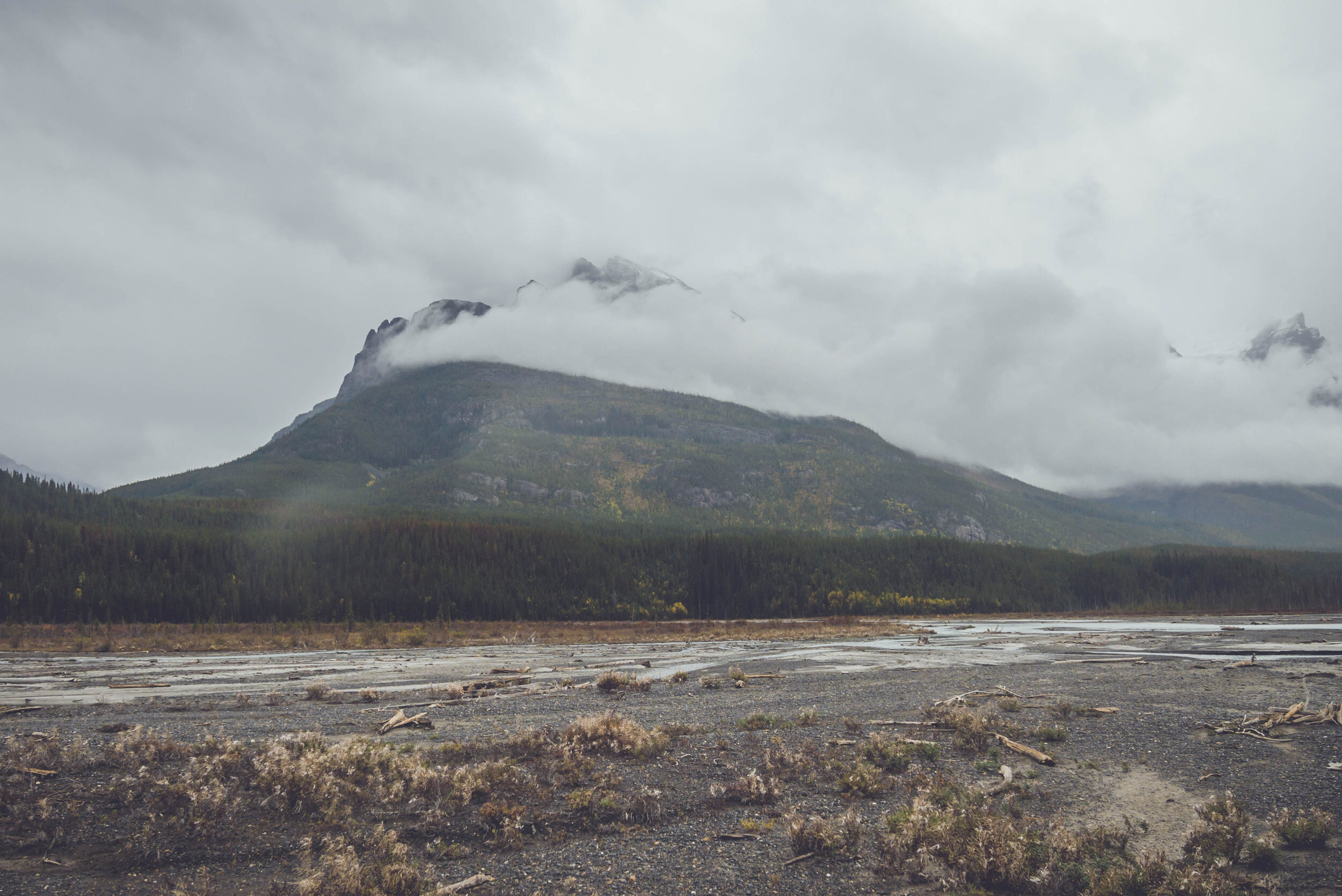
The Chaba Glacier was on the horizon. This is where we were heading and where the Chaba River starts!


Finding once again our way through thick woods to avoid having to cross a deep channel. In the end, we got our feet wet nonetheless. Part of the adventure!


Oh well, that’s a massive grizzly! These footprints were gigantic!

To say that Marty and I were shocked to see that enormous log jam was an understatement. We couldn’t determine if that was the main channel of the Chaba or just a secondary one. It was important for us to know the answer because if it was the main one, this would be a massive roadblock in our descent the next day. Walking around this pile of deadfalls was hard. It was so muddy and we just couldn’t identify a safe place to cross it. But studying this channel and the way it was eroding the muddy shores, we both came to the conclusion that this could not be the main channel of the Chaba. There were no rocks anywhere in the river and that was the main thing that triggered my suspicions.

After walking back and forth, we ended up inflating Marty’s raft to cross the deep and fast channel. It was well worth the trouble of unpacking all our stuff. I had tied a long rope to the raft and once Marty had paddled across, the only thing left for me to do was to pull it back to me and cross too. Once this operation over, we regained access to the flats and continued on in search of the main channel.


A real adventure wouldn’t be complete without an unexpected turn of events. With only 5km to go to reach the headwaters of the Chaba, we were bewildered by how tiny the river suddenly became. There were so many channels that none of them had enough water to packraft in. We almost walked the entire width of the valley just to confirm our doubts. At this point, we had two choices: we could either keep walking to the headwaters to check out the area or find a place to camp near the main channel where it would be wide, deep and fast enough for us to put in the next day. We chose the last option because it was the one that made the more sense. The next day’s forecast was calling for heavy rain. So having to start the day with a 5km walk before starting to paddle was not appealing to us.

We turned around, and following Marty’s suggestion, we decided to go camp at Fortress Lake.


The trail from the Chaba River to Fortress Lake was hard to find along the river. So we bushwacked for a few hundreds of meters before joining it. The trail would bring us into British Columbia where the lake is situated, right on the Alberta border.


There were so many junctions in the trail and we tried them all expect for one to find the campground on the side of the lake. We just couldn’t find it! [It turned out that after looking at another map back home, Marty told me that the campground was on the only trail we didn’t hiked on] We even climbed down a trail that led to the lake as per the little map that was posted on the trail. But it seemed like the high water of Fortress Lake was blocking our way.


We both checked our GPS but none of us could figure out why this campground was no where to be found. Blocked on the small beach down the trail, we turned around and tried to walk around the North side of the lake. But it was hard to navigate and led no where.

Marty checking his GPS.


The “trail” on the North shore of Fortress Lake.
After seeing how gorgeous the views of Mount Quincy were, I suggested we could just find a spot along the river to camp. This would also allow us to put our rafts in the water right a way in the morning. On our way down to the river, as we were chatting casually like we did all day on the trail, we experienced what most people wish they would never experience while in the backcountry… Marty was walking right in front of me and looking at his left at Fortress Mountain when I spotted a massive grizzly bear on the right side of the trail not even 5 meters in front of us. “SHIT THERE’S A BEAR”. That’s what came out of my mouth. As Marty turned around, we both instantly grabbed our bear spray and removed the safety clip, and put our thumb on the trigger. We kept screaming at him intensively… “HEY BEAR… BBBBEEEAAARRRRR… HEEEEYYYYY”. But the damn bear wouldn’t move. In fact, he turned his head towards us and loudly bluffed. I think I’ll never forget that sound. At the very same moment, I felt a real adrenaline rush going through my body. It was like a hot wave flowing from my feet up to my head. My right arm was also shaking a little bit. What lasted probably 30 seconds felt like an hour. But the bear eventually turned around and walked away into the bushes. Marty and I looked at each other and we were clearly a little shaken up from that encounter. It happened so fast and at a moment where we never expected it. And looking back at the situation, that’s exactly what the bear probably thought too. We surprised him as much as he surprised us. He let us know he wasn’t happy about it, and if only he knew that yeah… we were not happy either!!! We walked away from the area with our bear spray in hand for a while. Finding a place to camp was nerve racking but I think the spot we settled on was perfect. It was located right on the edge of the Chaba and between us and the trail was a bunch of massive fallen trees.


Chaba Glacier covered with clouds.
There was just enough space for our tents but after what had just happened, we couldn’t care less about sleeping inches away from one another. We both stayed in our tent for a little while, still tensed from the bear encounter. I took a few deep breaths in my tent and looking at Mount Quincy helped me to calm down.


After putting our gear to dry, we spent the evening chilling on our private little gravel beach where we built a fire and had dinner (and drank more whisky!).

Mount Quincy as viewed from camp.


Isn’t that a stunning glacier?


Exhausted, we both went to bed as darkness was setting in. The clouds were moving in, confirming that the next day would be a rainy one. No surprise here, I had a terrible night of sleep, waking up every hour or so. I am used to hear a wide array of sounds at night in the wilderness. And while I never pay attention to any of them, this specific night was different. I even got out of my tent once and scanned the area with my headlamp to make sure Yogi wasn’t back to pay us a visit. It was all in my head. I ended up waking up at 5:43AM and the rain started at 5:46AM. LOL. But the scenery was pretty anyway with the fog and the thick clouds covering the valley. I love this moody weather.

All packed up, we left our site bundled up in our rain gear. It was a little cold but paddling warmed us up quite rapidly.

I couldn’t help myself and had to stop a few times along the Chaba River to get off my packraft and admire the views. It was so different than the previous day but fir sure as beautiful. The fog was moving fast along the slopes and at times, it almost looked like a wildfire was burning on the slopes of the mountains.


The view from my seat! My Hyperlite Mountain Gear Windrider backpack performed flawlessly under the pouring rain and the paddle drippings. Everything stayed bone dry inside the pack.


My next stop was at the confluence of the Chaba River and the Athabasca River. My first thought was WOW, the Athabasca comes in fast! And that’s even upstream of the confluence. Add in all the water from the Chaba and you have a very fast and super wide river. I had concerns about how fast the flow would be. Would we encounter rapids along the way on the Athabasca? Marty was far ahead downstream of me and hoped he was doing fine. I got back in my packraft and paddled harder to catch up on him.

Athabasca River on the left, Chaba River on the right.
We did encountered a few sets of rapids. Some Class-II whitewater with two to three foot side waves. Nothing my Alpacka Caribou couldn’t handled but it was exciting as it was the fastest water I had ever paddled in. After the first ones, Marty and I were together again and we stopped at a few places to analyze the rapids we could see downstream. After a few other good ones, we stopped to bail our packrafts.


That’s where we modified our plans of getting out of the Athabasca at the bend in the river near the highway and get out at the Big Bend Campground instead. Sure it meant a 7km hike back to the car, but we were cold and wet. Walking would warm us up instead of standing still on the side of the highway waiting for someone to pick us up to drive us back to the trailhead.


As soon as we got off the water, we both started to shiver. We were soaked from head to toes and the temperature was barely above freezing. My legs were cramping up and I couldn’t feel them. We looked at each other and knew exactly what was happening. On the verge of hypothermia, we took our wet clothes off, put some dry ones on. I then did a few jumping-jacks to get my blood flowing back to my extremities again. A family who was camping there let us hide under their tarp to stay off of the rain. I light up my stove and proceeded to eat a homemade dehydrated macaroni and some pepperoni sticks I had kept for lunch. I was feeling better in no time. Keeping a set of dry clothing for this moment was key.


We took off for the trailhead on an incredibly muddy trail. But I didn’t care. I was now so warm that I was navigating through this mud field wearing shorts.


The road was pretty as usual. The 4-hour long drive left me plenty of time to reflect on this trip. What an adventure it was! One could easily think it was a little too much. But in all honesty, this is the kind of adventure I am perpetually dreaming about. I had an objective in mind before starting this trip and I can say: mission accomplished! I was able to experience a few situations that could surely occur on some of my next adventures: change of plans, bear encounter, hypothermia and general discomfort. I’d rather live these things while being close to home than when being a hundred kilometers from any road. All this happened despite the fact that Marty and I know what we are doing out there. We had the right gear for this trip, prepared accordingly for the expected weather conditions and never took any risks.
I am pretty sure that this was my last packrafting trip of the season with winter beginning to make its way to the Rockies. I have plenty of trips planned for next year. The only thing I hope is that they don’t include any bear encounter!
